The West Coast of the United States is earthquake country!
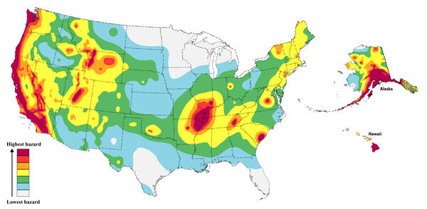
Areas shown in red on the map have a greater than a 75% chance of damaging earthquake shaking in a 100-year period. For more information, visit the USGS Hazard Toolbox or the Risk Map, 2023 50-State Long-term National Seismic Hazard Model
Sources/Usage: Public Domain. View Media Details
Earthquake hazard map showing peak ground accelerations having a 2 percent probability of being exceeded in 50 years, for a firm rock site. The map is based on the USGS models for the conterminous U.S. (2023), Hawaii (2021), and Alaska (2023). The models are based on seismicity and fault-slip rates and take into account the frequency of earthquakes of various magnitudes. Locally, the hazard may be greater than shown, because site geology may amplify ground motions.
 What you experience can depend on where you are.
Washington or Oregon
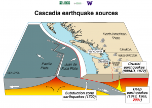
It’s possible you’ve never experienced an earthquake. Typically, the Pacific Northwest does not experience the more frequent, small earthquakes experienced near the San Andreas Fault. However, earthquakes and their cascading consequences pose a significant threat to the people, environment, infrastructure, and economy of the U.S. Pacific Northwest, which is along the Cascadia Subduction Zone, where two tectonic plates collide. A tectonic plate is a slab of solid rock composed of continental and oceanic lithosphere, or the earth’s upper-most crust and solid mantle).
(Source: https://pubs.usgs.gov/gip/dynamic/inside.html)
(Map: https://pnsn.org/education/pnw-earthquakes/sources)
Here, the Juan de Fuca Plate is thrust (or subducts) beneath the North American Plate. This region is susceptible to three types of earthquakes: deep (intraslab) earthquakes, subduction zone (megathrust) earthquakes, and shallow crustal earthquakes. For each of these earthquake types, earth scientists can use a variety of methods to estimate the probability of occurrence for future events, which constrains seismic hazard and informs building codes. Subduction zones are formed when Earth’s tectonic plates collide and one plate is forced beneath the other.
Historically, each of these earthquake types has caused significant damage to natural and built environments in northern California, Oregon, Washington, and southern British Columbia, Canada (referred to as “Cascadia”). The two largest earthquakes in recent years in Oregon, Scotts Mills (magnitude 5.6) and the Klamath Falls main shocks (magnitude 5.9 and magnitude 6.0) of 1993 were crustal earthquakes.
(Source: www.oregon.gov/dogami/earthquakes/pages/earthquakehome.aspx)
The timing of past earthquakes indicates that there is an 85% chance of a magnitude 6.5 (M6.5) or greater deep earthquake in the Puget Sound region; a 10-15% chance of an approximately M9 earthquake on the Cascadia Subduction Zone; and a 17% chance of a M6.5 or greater crustal fault earthquake in the Puget Sound region in the next 50 years. Individuals and communities can take simple steps to prepare for and reduce the impact of future earthquakes.
Sources:
https://www.usgs.gov/publications/earthquake-probabilities-and-hazards-us-pacific-northwest and Earthquake Probabilities and Hazards in the U.S. Pacific Northwest: https://pubs.usgs.gov/fs/2025/3050/fs20253050.pdf
https://pnsn.org/education/pnw-earthquakes/sources
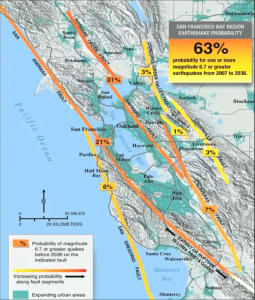 The Northern California Bay Area
A densely populated region on the West Coast, has a 65% probability for one or more M6.7 earthquakes or greater from 2007-2036. The 1868 estimated M6.8 earthquake in the Eastern Bay area along the Hayward Fault caused significant documented damage. Almost 40 years later, in 1906, a M7.9 earthquake struck San Francisco in the Western Bay area, where the surface rupture along the San Andreas Fault extended for almost 300 miles and caused enormous damage, large fires, and a significant loss of life. The M6.9 Loma Prieta earthquake of 1989 caused about $6 billion in damage and 63 fatalities, and exposed the strengths and weaknesses of modern building technology. Because the San Andreas and Hayward Faults run through such highly populated regions, it’s vital to be prepared.
Watch this video for more information.
SOURCE FOR CONTENT AND MAP: www.usgs.gov/media/videos/san-francisco-california-bay-area-earthquake-hazards-and-preparedness
Earthquake Probability Source: https://pubs.usgs.gov/fs/2025/3050/fs20253050.pd
Southern California
Southern California has the highest level of earthquake risk in the United States, with half of the expected financial losses from earthquakes in the Nation expected to occur in southern California. Sitting astride the Pacific – North American Plate boundary at the Big Bend of the San Andreas Fault, Southern California has over 300 faults capable of producing M6 and larger earthquakes. Affecting the millions of people living in the Los Angeles and San Diego metropolitan areas, this complex set of faults presents the greatest urban risk in the United States.
This map from the Southern California Earthquake Data Center shows historical earthquake events by magnitude and significant faults. Visit the site to select any colored icon to see specific information about each quake.
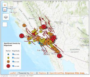
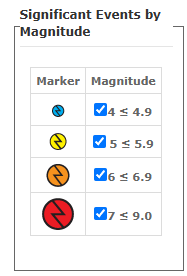
(Source:https://www.usgs.gov/programs/earthquake-hazards/science/southern-california-earthquake-hazards)
To learn more about all recent earthquakes, visit this USGS earthquake map webpage.

 Most Alerts Include: