This page highlights some of the most significant geoscience research and technical papers related to the ShakeAlert® System.
2026–2031 U.S. Geological Survey Strategy for a Hazard Ready Nation—Actionable Science for Risk Reduction
Alice B. Pennaz; Jack R. Friedman; Nathan J. Wood; and Jacqueline R. Meszaros
The USGS Strategy for a Hazard Ready Nation provides an approach that U.S. Geological Survey (USGS) researchers and staff can use to deliver actionable, user-focused science that supports risk-informed decision making aimed at reducing risk and losses across the Nation. The Strategy builds upon successful efforts within the USGS and seeks to promote and prioritize similar work in the future under an organized framework.
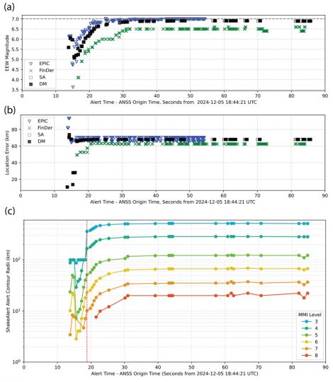
ShakeAlert Earthquake Early Warning System Performance During the Mw 7.0 Offshore Cape Mendocino Earthquake
Angela I. Lux; Jessie K. Saunders; Jessica Murray; Jeffrey J. McGuire; Maren Böse; Sumant Jha; Deborah Smith; Sydney Dybing; Carl Ulberg; Jacob Crummey; Stephen Crane; Richard M. Allen; Robert de Groot
The 5 December 2024 M7.0 offshore Cape Mendocino earthquake was a challenging test of the ShakeAlert earthquake early warning system due to its offshore epicenter and limited near-source station coverage. Nevertheless, ShakeAlert created an alert for this event with maximum warning times before potentially damaging shaking (intensity 6+) in the range of 5-55 s.
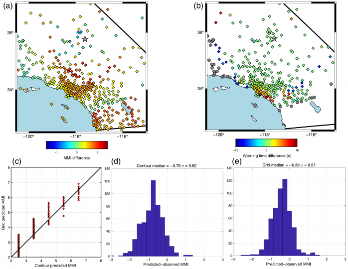
ShakeAlert® Version 3: Expected Performance in Large Earthquakes
McGuire, J.J.; Ulberg, C.W.; Lux, A.I.; Böse, M.; Andrews, J.R.; Smith, D.E.; Crowell, B.W.; Murray, J.R.; Henson, I.; Hartog, R.; Felizardo, C.; Huynh, M.; Aranha, M.; Parker, G.A.; Baltay, A.; Murray, M.H.; Biasi, G.P.; Guiwits, S.; Saunders, J.K.; Good, A.D.; Santillan, V.M.; Scrivner, C.W.; Szeliga, W.M.; Melbourne, T.I.; Kress, V.; de Groot, R.M.; McBride, S.K.; Given, D.; Allen, R.M.; Heaton, T.H.; Husker, A.; Thomas, V.; Tobin, H.J.; Jha, S.; Bunn, J.
The primary goal of the ShakeAlert System is to provide usable warning times before the arrival of damaging shaking. ShakeAlert software Version 3 is now live and includes improvements to all algorithms. ShakeAlert Version 3 also features using real-time geodetic data to characterize the magnitude growth in large earthquakes; the introduction of an alert pause procedure to compromise between speed near the epicenter and improved accuracy.
ShakeAlert®—Communication, Education, Outreach and Technical Engagement Strategic Vision
Robert Michael de Groot, Sara K. McBride, Margaret J. Vinci, Gabriel C. Lotto, Megan L. Anderson, Danielle F. Sumy, and Brian Terbush
Outreach and education about EEW may raise awareness of the overall earthquake threat and how people can best react when they receive an alert or feel shaking. ShakeAlert communication, education, outreach, and technical engagement (CEO&TE) efforts are highly collaborative and essential for the success of the ShakeAlert System. This strategic vision informs how the vast ShakeAlert CEO&TE Community operates and works together. The CEO&TE Community delineates a strategic framework that is intended to set the path for a long-term, sustainable approach to CEO&TE through three focus areas and five priorities.
Revised technical implementation plan for the ShakeAlert® system—An earthquake early warning system for the West Coast of the United States
Given, D.D., Allen, R.M., Baltay, A.S., Bodin, P., Cochran, E.S., Creager, K., de Groot, R.M., Gee, L.S., Hauksson, E., Heaton, T.H., Hellweg, M., Murray, J.R., Thomas, V.I., Toomey, D., and Yelin, T.S.
The U.S. Geological Survey (USGS), along with partner organizations, has developed an earthquake early warning (EEW) system called ShakeAlert for the highest risk areas of the United States: namely, California, Oregon, and Washington. The purpose of the system is to reduce the impact of earthquakes and save lives and property by providing alerts to institutional users and the public.
Phase 1 Technical Implementation Plan for the Expansion of the ShakeAlert Earthquake Early Warning System to Alaska
Cecily J. Wolfe, Natalia A. Ruppert, Douglas D. Given, Michael E. West, Valerie I. Thomas, Jessica R. Murray, and Ronni Grapenthin
The conference report accompanying the fiscal year (FY) 2022 Consolidated Appropriations Act (Public Law 117–103) for the U.S. Department of the Interior and related agencies directed the U.S. Geological Survey (USGS) to “work with the State of Alaska to develop an implementation plan to be completed within two years in order to put ShakeAlert/Earthquake Early Warning in Alaska” (p. 29).

Expected Warning Times from the ShakeAlert Earthquake Early Warning System for Earthquakes in the Pacific Northwest
McGuire, J.J., Smith, D.E., Frankel, A.D., Wirth, E.A., McBride, S.K., and de Groot, R.M.
The ShakeAlert earthquake early warning system has been live since October 2019 for the testing of public alerting to mobile devices in California and will soon begin testing this modality in Oregon and Washington. The Pacific Northwest presents new challenges and opportunities for ShakeAlert owing to the different types of earthquakes that occur in the Cascadia subduction zone. Many locations in the Pacific Northwest are expected to experience shaking from shallow crustal earthquakes (similar to those in California), earthquakes that occur deep within the subducted slab, and large megathrust earthquakes that occur primarily offshore.
Earthquake early warning ShakeAlert 2.0: Public rollout
Monica Kohler, Deborah E. Smith, Jennifer Andrews, Angela I. Chung, Renate Hartog, Ivan Henson, Douglas D. Given, Robert Michael de Groot, and Stephen Robert Guiwits
The ShakeAlert Earthquake Early Warning System is designed to automatically identify and characterize the initiation and rupture evolution of large earthquakes, estimate the intensity of ground shaking that will result, and deliver alerts to people and systems that may experience shaking, prior to the occurrence of shaking at their location. It is configured to issue alerts to locations within the West Coast of the U.S. In 2018, ShakeAlert 2.0 went live in a regional public test in the first phase of a general public rollout.
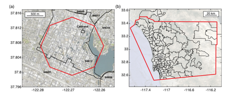
Latency and Geofence Testing of Wireless Emergency Alerts Intended for the ShakeAlert Earthquake Early Warning System for the West Coast of the United States of America
Sara K. McBride, Danielle F. Sumy, Andrea L. Llenos, Grace A. Parker, Jeffrey McGuire, Jessie K. Saunders, Men-Andrin Meier, Pascal Schuback, Douglas Given, and Robert de Groot
The ShakeAlert system uses, among other public alerting platforms like a mobile phone operating system, smartphone apps, and the Federal Emergency Management Agency Integrated Public Alert & Warning System (IPAWS). However, little is known about the IPAWS delivery latencies. Given that people may have only a few seconds of notice after they receive an alert to take a protective action before they feel earthquake shaking, quantifying latencies is critical to understanding whether the IPAWS system is useful for EEW. In this study, we developed new methods to test the IPAWS distribution system’s performance, both with devices in a controlled environment and as well as with a 2019 community-based feedback form, in Oakland and San Diego County, California, respectively.